
Degree Confluence, Central and Southern Turkey
Category: Degree Confluence, Projects | January 04, 2007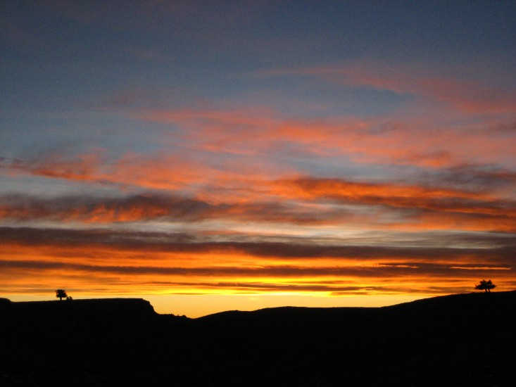
December 31, 2006 – January 03, 2007
This years’s bank holiday is allocated to our confluence project about which we’d been thinking for a long time. We had only four days. Therefore, we were well aware of the fact that it was gonna be a big hectic struggle from one point to another everyday. Having finished all the long and tiring preparations and gathered necessary equipment furnished with useful software, we hit the road at 01:00 o’clock.
39N 35E
31st of December 2006
We got to Pasali village following a very bumby road and parked the car near a house at the skirt of the vilage. Dogs vigorusly started barking. We wanted to take a two hour snooze in our seats until it gets light for photography and pulled the sleeping bags over. After an hour of uninterrupted sleep, a chap tapped on the window asking what we were doing there. Our answer was ready made saying we were from the agriculture department and came here for some botanics research! It was damn cold outside (-10C) and there couldn’t be any other reason to be there. They thought we were either smugglers or rubbers. As our country’s usual genuine hospitability he invited us inside his house for a cup of tea and breakfast. Having had some breakfast and patiently replied all the curieous questions, we set off and ran against the point. We found the point right at the place same as it was found before in a very strange way. We rushed back to the car in about 50 minutes holding some convincing sample plants we’d pulled on the way and started driving to the direction of Kayseri via Kalaba.
39N 36E
We knew we would have to drive past the ring road of Kayseri, a reputable carriageway with it cool congestion. It unfortunately costed us half an hour.Yet, wasting another 30 minutes further ahead due to an accident blocking the Sivas highway drove us insane. Having covered 122 km distance from the other point via Yıldırım village, we were as close as a mere 600 meters to 39N 36E. We made a flash approach and found ourselves back in our car rapidly moving on to the next confluence. On the way, we stopped for a quick visit to Sultanhanı Caravanserai near Bünyan. A tiny village with the same name surrounds the sight under restoration. We got long way ahead until reaching the close visinity of 38N37N before the sunset.
38N 37E
1st of January 2007
After the succesful confluence we headed down south with the stunning jagged steep summits of Tahtalı, Dibek and Binboğa ranges forming the very eastern part of the entire Taurus chain. In the afternoon, we arrived in the small town of Çardak where the real adventure began. We then had the north face views of famous Mt. Berit (3014m). Due to a battery problem encountered on our laptop computer we couldn’t check our map for a desperately needed final information of the area. Moreover, our route on the gps appeared to be very inaccurate and disapointing. As a matter of fact, we ended up often losing our way. Every time we had to ask directions from the natives and make up a reason to defeate the suspicious looks. The roads we followed were so bad that we hit the bottom of the car countless times. It became a nuicance routine having had to push the car or ice tool the roads to clean off the ice. We were desperately fighting with this challenge. Very eventually, we made it all the way around Mt Berit to its southern side and found Ortaoymak village where we’d approached as close as 980 meters to the confluence but sadly enough, it’d already been dark. Being really tired, we welcomed the new year in our deep sleep.
We quickly put the camping gear away at 06:30 the next day morning and marched to the point. We noted a well beaten narrow trail passing right on the trail. We wondered how many wolfs, sheep, dogs, shepards or dogs had already been wandering on this conluence which we spend tough hours to discover.
38N 36E
We guessed tracking the same route back would be dangerous because of dangerous icy passages. Hence, we chose a relatively longer but much safer way to Göksun via Elbistan.
Once again we were driving across the beautiful countryside. We kept going further approximately 15 km having arrived Saimbeyli and then we turned off due north at the signpost to Kızılağaç. We ascended up to 1250 meters in 19 km distance and parked the car along the road. We were gonna walk 1.6km all the way up to the point. A number of diogonal traverses ups and downs on the loose terrain were taclked till we reached the point situated right next to an unusable dirt road. It was a good time saving decision to follow that road all the way back to the car. Time was passing away and we gotta rush down south for the next confluence.
37N 36E
2nd of January 2007
When we finally arrived Kozan it was already dark. We had to let go of the next goal. The winter days were literally screwing us every single day. Never mind though, we were going to find the point anyway. The terrain flattened as we got near the Mediterranean coast. The classic getting lost comedy made us think to have been cursed. Back and forward but never shattered our gps beeped indicating it was 900 meters left to our baby. Having pitched up our tent we stared at the stars waiting for the next day.
Marathonsuddenly started when Derya said go! Nothing was easy in life we had cross irrigation streams with brilliant long jumps as if we were real athletes. We didn’t realize we were going to need those special techniques later on. We ought to be there and back as early as possible said Derya. That gave further motivation and we both increased our pace. We found a cairn very near the point and thought the first fellow having reached here might have put it. In return, we erected our reeds all the way around the confluence and got taken a well deserved group photo.
37N 35E
My lord! This was a cool intersection located almost beside the motorway with no exit. We didn’t have the luxury of approaching the point driving on the country roads due to our serious time limitations. We took a risk pulling over the car along the motorway. We left a stupid note displayed on the windscreen like we were going to be back in 20 minutes. There wasn’t anything we could do other than praying for our car not to be towed away. It was hilarious to see Derya and myself rapidly getting across and soon we were going to find ourselves trespassing citrus orchards leading us all the way to a military base. It wasn’t very clever to run against those premises having illegally left car and possessing a strange black device in the hand. So we slowed down and behaved as walking past the base. We admired the superb views the snowy Bolkar range and rushed almost the same back to our car. Having accomplished all the funny passages and yet more long jumps over the ditches and found our car intact in a single piece, Derya said good job mate! 6 over 6 not bad hey? Now you’re talking!Mersinwas the name of the game.
37N 34E
We drove past the chaotic city ofMersinand after a while took the turning on right from Erdemli aiming at Güzeloluk. We again turned right to fall into the Toros village road. We kept going and after a while an almost flat and wild plateau at 1800 m greeted us with its old majestic juniper trees. Whilst looking for a suitable road to reach our intersection as close as possible we realized our map was very inaccurate giving misleading information. That was a big deal as we couldn’t get any nearer than 8.5 km. We’d already wasted an hour trying to find a way but all the attempts ended up failure. It was better than nothing we quickly packed our rucksack and began a rapid steady pace trek against the time on these remote territories. Although the highland looked almost flat upon entering into details we saw it wasn’t the case. The wise junipers were as if staring and we picked up a lot of fossil stones on the ground, which proved the region of no has ever been before. It was a kind of creepy feeling being alone within the 100 square kilometer area but we were committed to make there without any hitches tanks to our solid outdoor experience. We spent a good two hours advancing up and down on the highlands. The point was discovered at edge of a former lake depression and we believe it could be recorded as one of the loneliest confluences on earth.
Were we done? Not yet we were afraid, as we had to cover the same distance back to our car. We witnessed the most beautiful sunset we have ever seen in our life times. All colors from red to yellow orange to purple were in an array above each other. That unbelievable occasion distracted us to picture taking until it finally got dark. Afterwards we were walking in the dark and Derya was ahead as always leading us the back to the civilization.
“17 km” said Derya when our car’s cat eyes reflected our headlamps. We were totally run out of energy. Because it was a hectic day and we did not take any food and water with us on the way. It was a well earned Turkish pizza with minced meat and ‘ayran (yoghurt drink)’ supper dreamed in both of our minds but soon we were going to find out there was no open restaurant at that time of the day in the rural country. Our next aim was lurking above Ermenek. As a matter of fact we were going to get headed there for an overheard nice simple restaurant on the way where we might find good food. So was it, we found the place and having impatiently waited for our meals we jumped onto whatever we see on the table, a situation of which must have made them think we were about to die of starvation. We parked the car near the road and fall asleep in our seats for a good night sleep.
37N 33E
3rd of January 2007
One more time we were getting cross because of wrong directions. It should’t be so much headache to find the Bucakkisla junction for the god’s sake. After some trial and failure we found the junction at last and moved accross another lovely country. We declared today the day of disappontments. Our map let us down showing Çukurbağ and Narlıdere villages over the incorrect coordinates.Moreover, the connection shown between those villages did not exist in reality. If we’d followed the directions on the map we would have had to tackle 200 meter technical rock wall! The weather which was briliant by the past three days got enourmously stormy and foggy. “No problem at all sir!”, we said to ourselves. We were definetely commited until the end. Nothing could distract us from our target. We found çukurbağ village from further north and succeeded in approaching the point by 1.2 km. The strong wing got so worse that it was gonna make us fly when we found the confluence. It was a nice and unexpected surprize having a luxury track extending right along our direction to the point.
It was time we drove back to Ankara as we needed to get back work next day. We believe we did a very good job having visited 8 points altogether 4 of which wasn’t discovered before in the midst of the short days of winter. However, we can’t deny being very lucky of mild weather conditions. We take pride in it!