
December 06-13, 2008
06th of December 2008 Saturday
40N 36E
Another bank holiday good for another adventure! We are going to aim 12 DCPs in 8 day time all accross the northeastern Turkey. Thanks to our previous DCP expeditions, we gained a lot of experience. As a matter of fact, we literally did not take chances on anything. We gathered geographical information such as Google Earth and Google Map images for route accession, digital topographic maps of various scales, downloaded Google Earth data with integrated maps for off-line access, uploaded maps and designated optimum confluence routes to our Garmin CSX GPS, a decent scale road book, Map Source software enabling us reach all the route data within moments notice. Moreover, we brought crampons, ice axes, a chain for the car tire, a tank of reserve fuel not to get stuck in the middle of nowhere, all sorts of camping equipment, a couple of radios and even a pair of pruning shears with an axe to overcome impassible vegetation of the Black Sea region. We were then well equipped and ready for the challenge more than ever!
We set off at 16:36 leaving the city congestion behind. Having arrived “Kayakışla-Taşpınar” junction we pulled over at a gas station and had a deep sleep in our car.
07 December 2008 Sunday
According to the news gathered at the station it wasn’t quite feasible to follow this divertion towards the point. Instead, we went a little more ahead and pulled off by “Şeyhşamil” turn. A 24 km drive took us to “Sulusaray” road. Then, with a few succesive left turns we reached near the DCP via “Selimiye” and “Alanyurt” villages. A hasty run made us step up right over the point.
We decided to go east to intersect the highway D 850 thinking it would save us some time. Enroute, we had a brief visit to a tiny museum in Sulusaray town exhibiting finds and stels from the nearby “Sebastiopolis” bronze-ancient site.
40N 37E
We approached the intersection via “Karacayir” road starting off almost by the downtown of Sivas. Locals are helpful with the directions. The chyristal clear images on Google Earth indicated a well beaten tarmac road passing very near the DCP. We pulled over and rushed uphill accross the rocky and steep terrain back and forth to get the accurate reading. It was such a beatiful landscape here, hilltops covered with black pine and willow trees, snowy mountain ranges and sparkling creeks.
On the way back, we did do a must: a visit the historic city of Sivas. Glamorous Gok Medrese with its gigantic twin minarets, a stone masonry wonder Uruciye medrese, Ulu mosque, Sivas congress building where the foundations of republic established were standing high as the oldest witnesses of history.
40N 38E
We turned left up north into “Suşehri” road. The road went up on a pass at 2000 meters. Then the winding way took us down to 1695 meter altitude where we decided to stay the night over. Mountanins around us looked rather spooky. Yet, the weather was quite stormy increasing the concerns for the next day.
08th of December 2008 Monday
“What a great place here is” We said, having waken up on a beautiful day. Crossing the creek by our car, we hit the slope all the way to the point. We hiked amongst lovely springs, mediterannean medlar trees, poplars, willows, berberis bushes and scrubs all over. We made it to the DCP and back enjoying the beautiful landscape.
40N 39E
The most the difficult DCPs are always for us! We don’t really think any confluence hunter would visit these remote locations ever again. Perhaps we are the most competent (crazy) confluence hunters!
A turn into north took us to “Ekecik” town. After a direct turn on the right by its center we were cruising along a rather scary dirt road which was very steep, winding and angulated. The northern parts of the track was under 20-30 cm snow and yet the altitude went well above 2200 at times was quite prone for making us get stuck should the harsh winter conditions set in.
It took a rather long journey to “Gazipınar” village via “Bakacak” and “Sakaloglu” villages. A bit before arriving in the last village our GPS indicated 1.2 km distance to the DCP. For the first time in our confluence life, we were gonna descend to the point. Looking around us we realized how steep and mountainous the landscape was. A few remote villages and white-out Munzur range was seen on the southern horizon. Wild pear trees and rosehip dotted slopes were all over the place. Thought, it was another fascinating region. Derya managed to drive all the same way back to the highway without skidding the car on the snow. It was a narrow escape this intersection!
So many lovely places to see in Turkey. However, we particularly tend to choose the lonely ones that no one else visited before. Because, we think that is the best way to know our country.
40N 41E
The city lights of Erzurum were seen on the horizon when we pulled off “Pasayurdu” road on the left. After selecting a scenic spot looking out on the city and close to the point we snuggled up in our sleeping bags and fell into a deep sleep.
09th of December 2008 Tuesday
Cold weather was good enough to wake us up. It was a mere early morning cross running exercise to reach the DCP. Straightaway to 40N 42E!
40N 42E
Çobandede bridge from Seljuk ages was a fantastically well preserved one spanning over the Aras river. Driving past the bridge on our right, a main road turns south to “Mus”. Another immediate turn into left will take you to the DCP right away via “Emreköy” and “Buğday” villages. We were lucky to discover a left hand side channel track getting us as near as 600 meters to the intersection point.
We took the same way back and decided to follow Narman route up north to reach our next target 41N 41E situated up on the impassible jungles of Kackar mountains national park. We had a long way to go.
41N 41E
It was such a superb journey to Camlıhemsin, the nearest town to 41N 41E in the northern part of Kackar range. Enroute, there was lots of incredible features: reddish fairy chimneys, sheer and tall rock walls, swift river streams, high waterfalls, deep lakes, handsome churches and mosques, winding roads. We drove past several dam construction sites going on a massive scale. These dams are built upon the downstream bits of the Coruh River, deemed the second best rafting destination of the world. In a strange way, despite being in such a mountainous area the altitude of the route was as low as 200 meters. That forms a microclimate here in this region enabling locals to grow all sorts of wet fruits like citrus and even olives!
When the night fell we had safely made it to the Black Sea coast leaving all the roadside constructions and hairpin bends wishing our brakes wouldn’t give away. Shortly after, it began to pour with rain which was gonna uninterruptedly carry on for the next 36 hours. After the long day we were really tired. We got to “Camlıhemsin” town and then “Ortan village”, the one closest to the DCP and fell asleep.
10th of December 2008 Wednesday
No luck today! The weather did not pick up at all. Moreover, the elevations above 500 meters was heavily snowing. Unfortunately, the forecast was indicating a similar day for the next day. Having driven 1600 km and turning around? We didn’t think so! We agreed on giving it a push no matter how worse the weather gets the next day.
This part of Kackar Mountains national park is called Fırtına valley, one of the 100 prime destinations on earth for wild life preservation. This gorgeous area is full of 60 degree slopes, extremely dense vegetation, wet, cold and snowy terrain, thorny scrubs and rhododendrons. In other words: impassable! There was literally no place for human being up above on these slopes we have been staring at for the whole day. Therefore, we can certainly say 41N 41E was gonna be the most difficult DCP we had ever tackled.
11th of December 2008 Thursday
It was a miracle! 06:30 in the morning, there left almost no clouds and even sun was shining upon the slopes of the range. The upper bits were all turned into a white coat.
On the way up to Ortan Village, we discovered a right hand side trail leading up to a mountain hut at 680 meters. A further path going up above took us all the way to 900 meter elevations. That indeed really eased our job. But, the rest of the way up awaiting was an ultimate challenge.
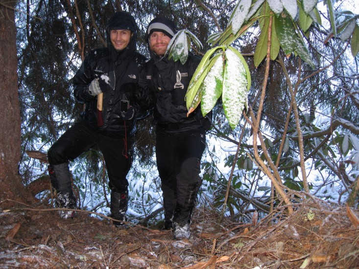
We weren’t even able to step on the real ground which was 2-3 meters down below. Instead, we got obliged to proceed through and over the thick branches. Eventually, Derya announced the very last 30 meter to the point which seemed to be by a spruce tree we saw ahead. It was nearly impossible to make it there. Luckily, we’d brought our pruning shears which helped out a lot. However, it was taking ages to clear out millions of branches and spiky ivies caught us tightly. It then took another good half an hour of vigorous fight with the obstinate flora just for getting through that bit. Derya successfully managed to read the accurate DCP coordinates on our GPS. We even succeed in arranging a confluence group photo setting up our tripod amongst the scrubs. The impossible was granted! We gave each other a great hug.
We were already exhausted and this was only the half way. Now, we had to repeat the same game all the way down to our vehicle in order to survive through the unmatchedly difficult conditions. Once we hit the trails it almost felt like driving on a motorway so we literally downhilled those bits quickly returning to our car. We’d got really wet and I was shivering. So was Derya doing poorly. Thanks to our appropriate wear and equipment, we got through the difficulties a little easier. It was high time to celebrate this well earned success with a cup of warm tea at the local tea house of Çamlıhemşin.
Since we had already lost a day chasing this DCP we realized we would have to skip the see confluences and carry on directly to 41N 39E in order to catch up with our schedule.
41N 39E
We pulled off “Canakcı” route 28-04. Getting near the point we pulled over and gave our tired bodies a good night sleep to recover for the next day’s attempt.
12th of December 2008 Friday
At a 500 meter distance to the DCP, we located a wooden suspension bridge to cross the Gorele river. Then we hit the steep and thorny slopes up over the ridge and then down to the point. We got stuck several times due to excessive spiky ivies (especially black berries were of a particular problem). It didn’t matter much though, thanks to our previous experience and the prune mate!
No whimper mate! Don’t think one would really need accurate maps to reach such places. Nowadays, indeed Google Earth provides sharp and accurate images which duly helps a hunter locate and access these points. Not really rocket science, take it easy dudes! Lift your bum and obtain some captures before leaving home! That would be fare enough to get you around.
41N 37E
The name of the game, “Ikizce” road will take you close to the point driving past “Unye” due east. Then go straight up on this route and park by 500 meter distance to the spot. Easy, lemon squeezy! Bummer! It fell dark again.
13th of December 2008 Saturday
We got up and rushed down the slope once again to the target. The point got easily granted and soon we were gonna be driving back to the Black Sea coast. The next and the last: 41N 36E. We were slowly getting home sick.
41N 36E
13 December 2008 Saturday
Derya recommended us try Menemen at breakfast in Kavak town. Menemen, a famous Turkish dish containing scrambled eggs with fatter cheese, green pepper and tomato. The gorgeous taste of menemen goes really well with perfectly steeped Turkish tea and freshly baked pita bread. The clock was ticking so we soon reverted back to our final mission.
This time the appropriate route was “Bukcegiz” turn into south 1 km before arriving “Kavak” town center from “Samsun” direction. Be careful, the sign post is facing the other way : o ) Leaving the village behind, the road got buried under newly fallen snow but our winter snow tires were far better equipped than the terrain. So it was no worries.
Thorns, thorns, ups, downs and more thorns. It was now an already acknowledged Black sea classic. Well, I can’t deny having walked past substantial numbers of horn beam and oak woodlands as well. Moreover, the fog at the distance was a bonus to the peaceful landscape.
We finally finished another marvelous journey. In 8 days and 2670 km, we witnessed truly admirable landscapes that no one else has ever been before. Despite the short days and winter conditions, we are proud to have reached 10 intersections including 3 new raising the number of visited DCPs across Turkey to 79. Our expedition was definitely a great achievement. To be honest with you, we are already looking forward to the very next one!